 Wikipedia lead image (see Wikipedia article for licensing)
Mount Agassiz — Summits 44.9 Miles WSW of Chapman Inn
Grafton County, New Hampshire · USGS Bethlehem Quadrangle · GNIS 865206
44.9 miles west-southwest of Chapman Inn, on the USGS Bethlehem topographic quadrangle, Mount Agassiz is a summit recorded in Grafton County, New Hampshire by the federal Geographic Names Information System.
Wikidata short description: “mountain in Grafton County, New Hampshire, United States”
Landmark Profile
Classification & USGS reference
The USGS Bethlehem 7.5-minute topographic quadrangle places Mount Agassiz in Grafton County, New Hampshire (FIPS 33/009), classified as a summit in the federal GNIS (Feature ID 865206). Last revised by the Board on Geographic Names on 11/10/2020.
Coordinates & physical setting
Mount Agassiz sits at 44.26612° N, 71.67669° W (DMS 44°15′58″ N, 71°40′36″ W).
Other summits in Grafton County, New Hampshire
Grafton County, NH contains 93 summits catalogued in the USGS Geographic Names Information System, counting Mount Agassiz itself. The ones closest to Mount Agassiz:
| Feature | USGS Quadrangle | Elevation | Distance |
|---|---|---|---|
| Cleveland Mountain | Bethlehem | — | 0.6 mi |
| Lewis Hill | Bethlehem | — | 0.8 mi |
| Abbot Hill | Franconia | 1,729 ft | 2.2 mi |
| Garnet Mountain | Bethlehem | — | 2.2 mi |
| Priest Hill | Franconia | — | 2.8 mi |
| Scrag Hill | Franconia | — | 3.1 mi |
| Russell Hill | Bethlehem | — | 4.1 mi |
| Bickford Mountain | Franconia | — | 4.3 mi |
| Scarface Mountain | Franconia | — | 4.4 mi |
| Pine Knob | Twin Mountain | — | 4.4 mi |
Features on the USGS Bethlehem Quadrangle
The Bethlehem 7.5-minute topographic quadrangle holds 18 catalogued natural features alongside Mount Agassiz. A sampling nearest to this location:
| Feature | Type | County | Offset |
|---|---|---|---|
| Cleveland Mountain | Summits | Grafton County, NH | 0.6 mi |
| Lewis Hill | Summits | Grafton County, NH | 0.8 mi |
| Garnet Mountain | Summits | Grafton County, NH | 2.2 mi |
| Black Brook | Streams | Grafton County, NH | 2.3 mi |
| Miller Pond | Reservoirs | Grafton County, NH | 2.6 mi |
| Barrett Brook | Streams | Grafton County, NH | 3.7 mi |
| Black Brook | Streams | Grafton County, NH | 3.8 mi |
| Russell Hill | Summits | Grafton County, NH | 4.1 mi |
| Fowler Brook | Streams | Grafton County, NH | 4.1 mi |
| Hatch Brook | Streams | Grafton County, NH | 4.4 mi |
Historical record
Also known as: Mt. Agassiz.
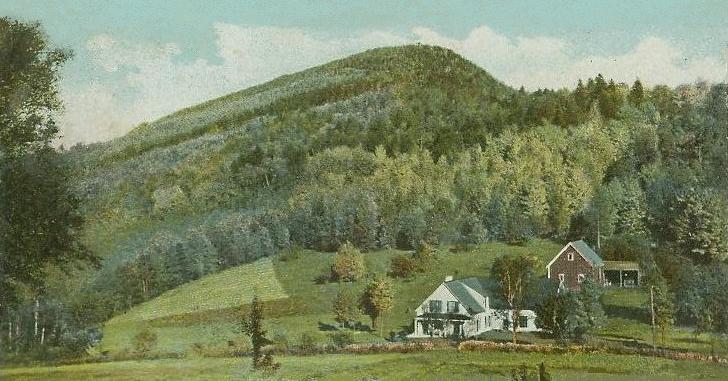
Mount Agassiz is a peak in the White Mountains of New Hampshire with an elevation of 2,378 feet (725 m). It is located in the town of Bethlehem in Grafton County. Originally named Peaked Hill, it is named in honor of Louis Agassiz. Extended history on Wikipedia →
Visiting from Chapman Inn
Distance, bearing & drive time
Chapman Inn sits 44.9 miles west-southwest (bearing WSW) of Mount Agassiz. At moderate back-road speeds the drive runs about 77 minutes — comfortably inside a half-day outing window after breakfast.
Best time to visit
Accessible May through November in most years. At this latitude (44.266°), the shoulder seasons are workable — April and November can be comfortable on mild years. At 44.9 miles from the Inn, block the full day — sunrise start, late return, packed meals. Conditions at Mount Agassiz track the nearby Cleveland Mountain summit (0.6 mi away) closely — if that is runnable, so is this.
Nearest features to Mount Agassiz
| Feature | Type | County | Distance |
|---|---|---|---|
| Cleveland Mountain | Summits | Grafton County, NH | 0.6 mi |
| Lewis Hill | Summits | Grafton County, NH | 0.8 mi |
| Beaver Brook | Streams | Grafton County, NH | 1.9 mi |
| Abbot Hill | Summits | Grafton County, NH | 2.2 mi |
| Garnet Mountain | Summits | Grafton County, NH | 2.2 mi |
Frequently Asked Questions
Where is Mount Agassiz located?
Mount Agassiz is in Grafton County, New Hampshire, approximately 44.9 miles west-southwest of Chapman Inn in Bethel, Maine. It appears on the USGS Bethlehem topographic quadrangle.
How far is Mount Agassiz from Chapman Inn?
The drive runs about 77 minutes, 44.9 miles west-southwest (bearing WSW) of the Inn.
What type of natural feature is Mount Agassiz?
The U.S. Geological Survey classifies Mount Agassiz as a summit, catalogued under GNIS Feature ID 865206 on the Bethlehem quadrangle.
When is the best time to visit Mount Agassiz?
Accessible May through November in most years.
What other names has Mount Agassiz been known by?
Alternate or historical names on record: Mt. Agassiz.
How many other summits are in Grafton County, New Hampshire?
GNIS lists 92 other summits in Grafton County, New Hampshire.
Wikidata: Q34880353.