 Wikipedia lead image (see Wikipedia article for licensing)
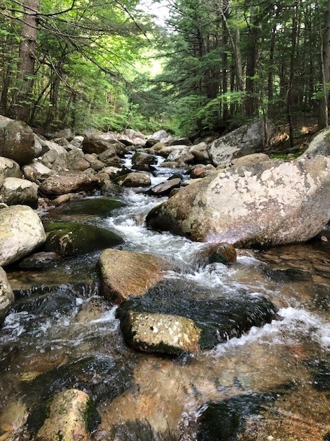
Whiteface River — Streams 47.8 Miles SW of Chapman Inn
Carroll County, New Hampshire · USGS Center Sandwich Quadrangle · GNIS 872919
47.8 miles southwest of Chapman Inn, on the USGS Center Sandwich topographic quadrangle, Whiteface River is a stream recorded in Carroll County, New Hampshire by the federal Geographic Names Information System.
Wikidata short description: “river in New Hampshire, United States”
Landmark Profile
Classification & USGS reference
The USGS Center Sandwich 7.5-minute topographic quadrangle places Whiteface River in Carroll County, New Hampshire (FIPS 33/003), classified as a stream in the federal GNIS (Feature ID 872919). Catalogued in GNIS since 08/27/1980.
Coordinates & physical setting
Whiteface River sits at 43.86368° N, 71.38924° W (DMS 43°51′49″ N, 71°23′21″ W).
As a linear feature its source lies near 43.94118° N, 71.43174° W (DMS 43°56′28″ N, 71°25′54″ W) — useful for anglers and paddlers tracing the upstream end.
Other streams in Carroll County, New Hampshire
Carroll County, NH contains 152 streams catalogued in the USGS Geographic Names Information System, counting Whiteface River itself. The ones closest to Whiteface River:
| Feature | USGS Quadrangle | Distance |
|---|---|---|
| Tilton Brook | Center Sandwich | 0.2 mi |
| Captain Neal Brook | Mount Tripyramid | 1.4 mi |
| Heath Brook | Center Sandwich | 1.7 mi |
| White Brook | Mount Tripyramid | 1.7 mi |
| Tewksberry Brook | Mount Chocorua | 1.9 mi |
| Atwood Brook | Tamworth | 2.9 mi |
| Mill Brook | Tamworth | 3 mi |
| East Branch Whiteface River | Mount Tripyramid | 3.1 mi |
| Meadow Brook | Center Sandwich | 3.2 mi |
| Cold River | Center Sandwich | 3.4 mi |
Features on the USGS Center Sandwich Quadrangle
The Center Sandwich 7.5-minute topographic quadrangle holds 8 catalogued natural features alongside Whiteface River. A sampling nearest to this location:
| Feature | Type | County | Offset |
|---|---|---|---|
| Tilton Brook | Streams | Carroll County, NH | 0.2 mi |
| Pond Brook | Streams | Grafton County, NH | 0.5 mi |
| Bragg Ledge | Benches | Carroll County, NH | 1.1 mi |
| Heath Brook | Streams | Carroll County, NH | 1.7 mi |
| Maple Ridge | Ridges | Carroll County, NH | 1.8 mi |
| Meadow Brook | Streams | Carroll County, NH | 3.2 mi |
| Cold River | Streams | Carroll County, NH | 3.4 mi |
Historical record
The Whiteface River is a 5.9-mile-long (9.5 km) river rising in the White Mountains of New Hampshire in the United States. Its waters flow by way of the Cold River, Bearcamp River, Ossipee Lake, the Ossipee River and the Saco River into the Gulf of Maine, an arm of the Atlantic Ocean. Open the Wikipedia article →
Visiting from Chapman Inn
Distance, bearing & drive time
Chapman Inn sits 47.8 miles southwest (bearing SW) of Whiteface River. At moderate back-road speeds the drive runs about 82 minutes — comfortably inside a half-day outing window after breakfast.
Best time to visit
Best observed in late spring and early summer when flow is strong and banks are visible. At this latitude (43.864°), the shoulder seasons are workable — April and November can be comfortable on mild years. At 47.8 miles from the Inn, block the full day — sunrise start, late return, packed meals. Conditions at Whiteface River track the nearby Tilton Brook stream (0.2 mi away) closely — if that is runnable, so is this.
Nearest features to Whiteface River
| Feature | Type | County | Distance |
|---|---|---|---|
| Tilton Brook | Streams | Carroll County, NH | 0.2 mi |
| Pond Brook | Streams | Grafton County, NH | 0.5 mi |
| Bragg Ledge | Benches | Carroll County, NH | 1.1 mi |
| Captain Neal Brook | Streams | Carroll County, NH | 1.4 mi |
| Tasker Hill | Summits | Carroll County, NH | 1.4 mi |
Frequently Asked Questions
Where is Whiteface River located?
Whiteface River is in Carroll County, New Hampshire, approximately 47.8 miles southwest of Chapman Inn in Bethel, Maine. It appears on the USGS Center Sandwich topographic quadrangle.
How far is Whiteface River from Chapman Inn?
The drive runs about 82 minutes, 47.8 miles southwest (bearing SW) of the Inn.
What type of natural feature is Whiteface River?
The U.S. Geological Survey classifies Whiteface River as a stream, catalogued under GNIS Feature ID 872919 on the Center Sandwich quadrangle.
When is the best time to visit Whiteface River?
Best observed in late spring and early summer when flow is strong and banks are visible.
How many other streams are in Carroll County, New Hampshire?
GNIS lists 151 other streams in Carroll County, New Hampshire.
Wikidata: Q7995843.